
By John Lanchbery and Ishbel Beatty
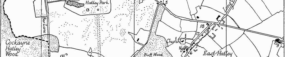
A 19th century map of Hatley, Cambridgeshire.
The medieval parishes of East Hatley and Hatley St George lie in the gently rolling countryside of south west Cambridgeshire. Ermine Street, the Roman road from London to Lincoln, is about two and a half miles to the east and the old east-west track, now known as the Clopton Way, runs about one and a half miles to the south.
In the Domesday Book (1086) the villages are called Hatelaie, the word ‘laie’ or ‘ley’ meaning a woodland clearing. They are still well-wooded with much of the ancient woodland remaining.
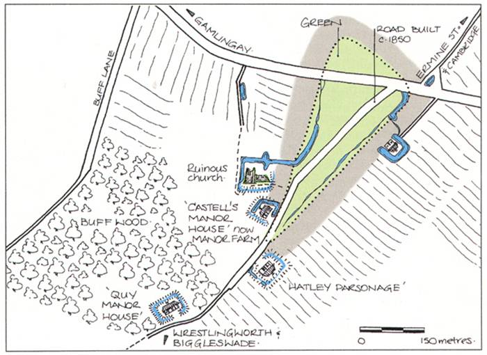
A feature of the Hatleys is that the more important buildings were once surrounded by moats. These can still be seen, especially in East Hatley. St. Denis’ church in East Hatley retains its moat, as do the ruins of what is thought to be Quy Manor in the ancient Buff Wood, which in 1086 belonged to Picot, the sheriff of Cambridge. Buff Wood is now a Site of Special Scientific Interest (SSSI) and looked after by the Hatley Estate.
Hungry Hatley
Neither village was ever large, possibly because the clay soil yielded poor crops until the land was properly drained with the aid of machinery in the twentieth century.
So poor were the parishes that by 1218 Hatley St George was known as ‘Hungry Hatley’. It later took the name of its principal landowners, the St. George family, who lived in the area from the thirteenth to the seventeenth centuries.
Enclosure
The Domesday Book records 24 families in East Hatley and 17 in Hatley St George. Both villages had grown by 1377 when the first English poll tax was levied, but they had declined considerably by Tudor times, largely due to the enclosure of previously common land. By 1563 there were just nine scattered households in East Hatley and only four in Hatley St George.
Land enclosure, mainly for sheep rearing, caused widespread depopulation of the region in the late fifteenth and early sixteenth centuries, with the nearby village of Clopton being completely abandoned.
The enclosure of fields in East Hatley by the Castell family began in the 15th century. By the mid 17th century, when they owned virtually all the parish, it was complete and most of the land was pasture.
Civil War
Hatley St George was mainly arable until the 17th century when the St. George family was fined for supporting Charles I in the Civil War (1642 to 1649) and had to sell the estate to the wealthy Cotton family, who kept it until the eighteenth century.
A similar fate befell the Castells, who had lost their fortune in the Civil War. In 1661, their lands in East Hatley passed to Sir George Downing, after whom Downing Street is named and whose grandson’s money paid for the foundation of Downing College, Cambridge.
It took until the nineteenth century for the Hatley villages’ populations to recover to where they were in the time of the Domesday Book. Today 185 people live in the two parishes (2021 census), which were united to form a single parish in 1957.
All change
The layout of the villages has changed considerably over the centuries – the exact location of old Hatley St George is unclear but, in medieval times, East Hatley was arranged around a triangular village green, with its moated church, manor and parsonage in the southern corner.
The road that ran through the middle of the medieval village, now a cul-de-sac, was once part of an important route from Cambridge to Oxford, through Biggleswade.
By the 18th century, East Hatley had almost disappeared, with a parsonage at one end of the green and a farmhouse at the other. From the 1850s, houses began to be built on the green itself, with Main Street moved to run through the centre of it, where it remains forming the backbone of the present village.
Downing College
Downing College administered the estate surrounding the village from 1800 to 1946. They improved some of the cottages, managed the farms through years of agricultural depression and developed the land during the Second World War.
Hatley St George has remained as one with the estate of Hatley Park, which has passed through the hands of a number of different owners since the 17th century.
One of them, Thomas St. Quintin, added to the memorials in the church, and left initials on the new public house which he built in 1850. They can still be seen on what is now a private residence.
Source
This article is based on Archaeology of Cambridgeshire, Vol. 1: South West Cambridgeshire, by Alison Taylor, pp 68-71 and published by Cambridgeshire County Council, 1977. ISBN 1-870724-84-4. The book is in the Cambridgeshire Collection at Cambridge Central Library.
Other links
Hatley Park listing – Historic England.
More about Hatley – British history online.
History of Hatley (taken from various sources – may contain errors) – Bernard O’Connor.
Establishment of the Parish Council – PDF.
Hatley, Cambridgeshire – Wikipedia.
The Clopton Way – Cambridgeshire County Council leaflet (PDF).
First published on the original Hatley website, May 2004; with minor changes Oct 2018, May 2023, Mar 2025.