
By Peter Mann
It used to be said upon receiving a new phone directory, the first thing a householder would do was look up their own entry – not so common these days with the residential listings in what turned out to be the very last Phone Book (dated 2018/2019) only covering 56 pages.
I find the same fascination applies to books, for I cannot resist picking up one on Cambridgeshire, the English landscape or churches and flicking to the index to see if either of our Hatleys are listed.
As you might expect, they are in specific Cambridgeshire books – such as Sir Nikolaus Pevsner’s brilliant series The Buildings of England and Arthur Mee’s equally ground-breaking The King’s England series – having individual East Hatley and Hatley St George entries.
But Hatley being Hatley and a rather obscure place even to some who live in Arrington, Croydon, Gamlingay and Potton, there are few mentions in more general books – which makes it all the more exciting when one does crop up. I well remember having W G Hoskins’ English Landscapes as my bedtime reading and nearly falling out of bed when I found a mention of East Hatley!
So, I thought it might be useful to include those mentions on this website – newly typed out, faithfully following the punctuation and grammar of the originals.
If you have any books which include something on Hatley, please let me peter@buzzassociates.co.uk know so I can include it here. So far we have…
- The Buildings of England – Cambridgeshire by Nikolaus Pevsner
- The King’s England – Cambridgeshire by Arthur Mee
- English Landscapes by W G Hoskins
- The Cambridgeshire Landscape by Christopher Taylor
- Surveying the Domesday Book by Simon Keith
The Buildings of England – Cambridgeshire
by Nikolaus Pevsner
Buildings of England, Cambridgeshire, by Sir Nikolaus Pevsner – the first (1954) and second (1970) editions with snapshots of East Hatley.
Buildings of England, Cambridgeshire, by Sir Nikolaus Pevsner – the first (1954) and second (1970) editions with snapshots of Hatley St George.
The Buildings of England – Cambridgeshire, by Sir Nikolaus Pevsner, 1902-83. There are three editions, of which I have the first two: the first edition was published in 1954 by Penguin Books and includes our Hatleys on pages 261 and 325. The second edition, again from Penguin Books (ISBN 0 14 071010 8), lists us on pages 335 and 405.
By the time of the third edition in 2014, Yale University Press had taken over the series (now under the banner ‘Pevsner Architectural Guides: Buildings of England’, with the Cambridgeshire edition (ISBN 9780300205961) updated / added to / rewritten in parts by Simon Bradley, who made this ‘charming’ video Pevsner Architectural Guide to Cambridgeshire – a short film to promote it.
The fascinating thing is to compare the entries – at least for the first two editions: if you have the third edition and wouldn’t mind lending it to me, I’ll add the Hatley entries to these originals:
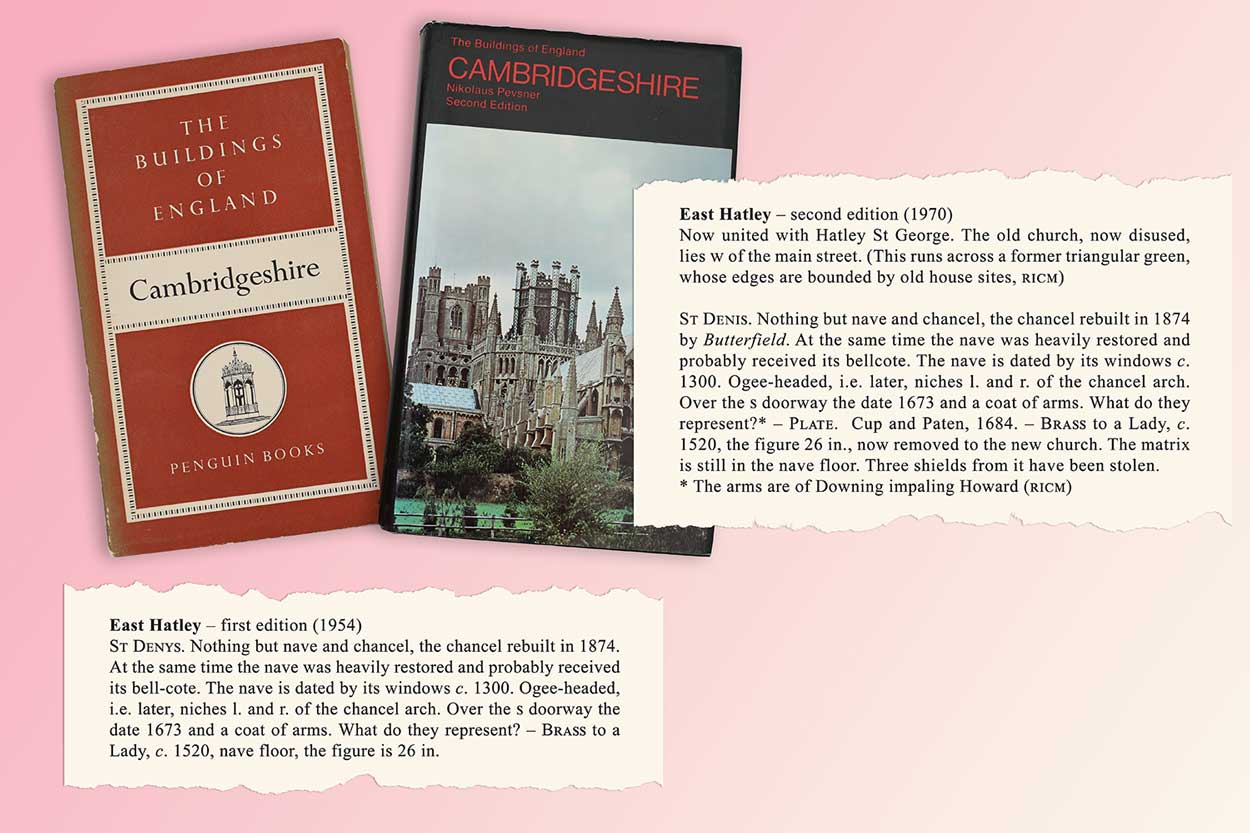
Buildings of England – Cambridgeshire, by Nikolaus Pevsner, 1902- / Pages 261 and 325. First edition, 1954; Penguin Books.
East Hatley
St Denys. Nothing but nave and chancel, the chancel rebuilt in 1874. At the same time the nave was heavily restored and probably received its bell-cote. The nave is dated by its windows c. 1300. Ogee-headed, i.e. later, niches l. and r. of the chancel arch. Over the S doorway the date 1673 and a coat of arms. What do they represent? – Brass to a Lady, c. 1520, nave floor, the figure is 26 in.
Hatley St George
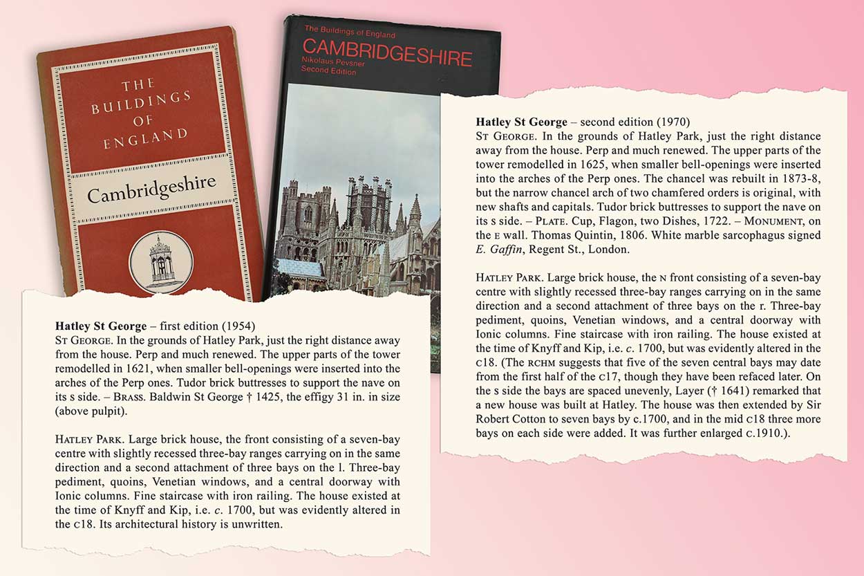
St George. In the grounds of Hatley Park, just the right distance away from the house. Perp and much renewed. The upper parts of the tower remodelled in 1621, when smaller bell-openings were inserted into the arches of the Perp ones. Tudor brick buttresses to support the nave on its s side. – Brass. Baldwin St George † 1425, the effigy 31 in. in size (above pulpit).
Hatley Park. Large brick house, the front consisting of a seven-bay centre with slightly recessed three-bay ranges carrying on in the same direction and a second attachment of three bays on the l. Three-bay pediment, quoins, Venetian windows, and a central doorway with Ionic columns. Fine staircase with iron railing. The house existed at the time of Knyff and Kip, i.e. c. 1700, but was evidently altered in the C18. Its architectural history is unwritten.
The Buildings of England – Cambridgeshire, by Sir Nikolaus Pevsner, 1902-83 / Pages 335 and 405. Second edition, 1970, reprinted 1989; Penguin Books, ISBN 0 14 071010 8.
East Hatley
Now united with Hatley St George. The old church, now disused, lies W of the main street. (This runs across a former triangular green, whose edges are bounded by old house sites, RCHM)
St Denis. Nothing but nave and chancel, the chancel rebuilt in 1874 by Butterfield. At the same time the nave was heavily restored and probably received its bellcote. The nave is dated by its windows c. 1300. Ogee-headed, i.e. later, niches l. and r. of the chancel arch. Over the S doorway the date 1673 and a coat of arms. What do they represent?* – Plate. Cup and Paten, 1684. – Brass to a Lady, c. 1520, the figure 26 in., now removed to the new church. The matrix is still in the nave floor. Three shields from it have been stolen. * The arms are of Downing impaling Howard (RCHM)
Hatley St George
St George. In the grounds of Hatley Park, just the right distance away from the house. Perp and much renewed. The upper parts of the tower remodelled in 1625, when smaller bell-openings were inserted into the arches of the Perp ones. The chancel was rebuilt in 1873-8, but the narrow chancel arch of two chamfered orders is original, with new shafts and capitals. Tudor brick buttresses to support the nave on its S side. – Plate. Cup, Flagon, two Dishes, 1722. – Monument, on the E wall. Thomas Quintin, 1806. White marble sarcophagus signed E. Gaffin, Regent St., London.
Hatley Park. Large brick house, the N front consisting of a seven-bay centre with slightly recessed three-bay ranges carrying on in the same direction and a second attachment of three bays on the r. Three-bay pediment, quoins, Venetian windows, and a central doorway with Ionic columns. Fine staircase with iron railing. The house existed at the time of Knyff and Kip, i.e. c. 1700, but was evidently altered in the C18. (The RCHM suggests that five of the seven central bays may date from the first half of the C17, though they have been refaced later. On the S side the bays are spaced unevenly, Layer († 1641) remarked that a new house was built at Hatley. The house was then extended by Sir Robert Cotton to seven bays by c.1700, and in the mid C18 three more bays on each side were added. It was further enlarged c.1910.).
The King’s England – Cambridgeshire
by Arthur Mee
The Cambridgeshire edition of Arthur Mee’s The King’s England was published in 1939.
According to Wikipedia, this series of topographical and historical books, written and edited by Arthur Mee (1875-1943) in 42 volumes, was a modern Domesday Book and that the compilers had travelled half-a-million miles in order to complete their task. The first, introductory, volume was published in 1936.
The King’s England – Cambridgeshire, published in 1939, has this on East Hatley and Hatley St George:
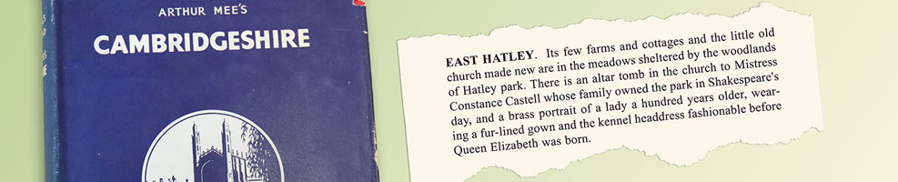
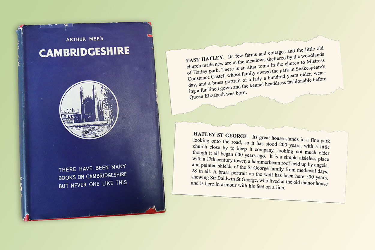
East Hatley. Its few farms and cottages and the little old church made new are in the meadows sheltered by the woodlands of Hatley park. There is an altar tomb in the church to Mistress Constance Castell whose family owned the park in Shakespeare’s day, and a brass portrait of a lady a hundred years older, wearing a fur-lined gown and the kennel headdress fashionable before Queen Elizabeth was born.
Hatley St George. Its great house stands in a fine park looking onto the road; so it has stood 200 years, with a little church close by to keep it company, looking not much older though it all began 600 years ago. It is a simple aisleless place with a 17th century tower, a hammerbeam roof held up by angels, and painted shields of the St George family from medieval days, 28 in all. A brass portrait on the wall has been here 500 years, showing Sir Baldwin St George, who lived at the old manor house and is here in armour with his feet on a lion.
English Landscapes
by W G Hoskins
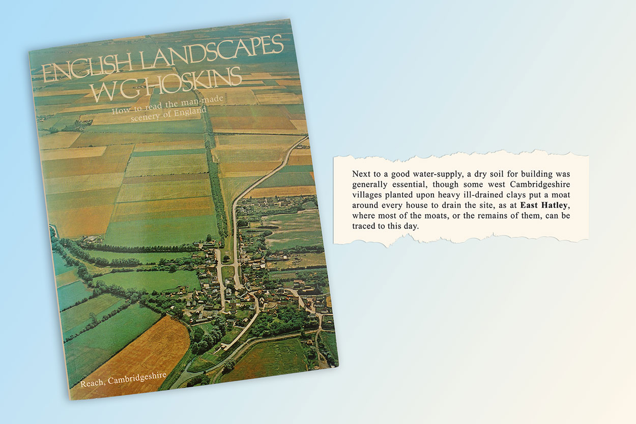
English Landscapes by W G Hoskins – page eight mentions East Hatley’s moats.
Just a small, but interesting, mention of East Hatley – a bit of an honour, for W G Hoskins (1908-92) is credited with establishing English local history as a formal academic discipline.
His pioneering book The Making of the English Landscape, first published in 1955 (ISBN 0140154108), is still well worth reading.
Here’s his piece on East Hatley, from English Landscapes, which was published in 1973 by BBC Publications (ISBN 0 563 12407 5) to go with of a TV series he made:
Next to a good water-supply, a dry soil for building was generally essential, though some west Cambridgeshire villages planted upon heavy ill-drained clays put a moat around every house to drain the site, as at East Hatley, where most of the moats, or the remains of them, can be traced to this day.
The Cambridgeshire Landscape
by Christopher Taylor
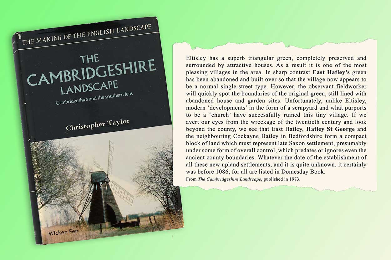
Cambridgeshire Landscape by Christopher Taylor. It includes detail of the landscape around the Hatleys.
Hoskins’ comment is complemented by the more detailed look at the Cambridgeshire landscape in Christopher Taylor’s book of that name – part of a series on the making of the English landscape.
Because it’s an overall look at the county’s landscape, I’ve included more than just a strict mention of the Hatleys to put his text into context.
The Cambridgeshire Landscape by Christopher Taylor (1935-2021) – part of The Making of the English Landscape series. Published in 1973 by Hodder and Stoughton, ISBN 0 340 15460 8.
Page 79
Eltisley has a superb triangular green, completely preserved and surrounded by attractive houses. As a result it is one of the most pleasing villages in the area. In sharp contrast East Hatley’s green has been abandoned and built over so that the village now appears to be a normal single-street type. However, the observant fieldworker will quickly spot the boundaries of the original green, still lined with abandoned house and garden sites. Unfortunately, unlike Eltisley, modern ‘developments’ in the form of a scrapyard and what purports to be a ‘church’ have successfully ruined this tiny village. If we avert our eyes from the wreckage of the twentieth century and look beyond the county, we see that East Hatley, Hatley St George and the neighbouring Cockayne Hatley in Bedfordshire form a compact block of land which must represent late Saxon settlement, presumably under some form of overall control, which predates or ignores even the ancient county boundaries. Whatever the date of the establishment of all these new upland settlements, and it is quite unknown, it certainly was before 1086, for all are listed in Domesday Book.
Page 144 – enclosure [1]
By the sixteenth century enclosure had become common in the upland parts of the county. The surviving evidence is scanty… some evidence is contained in the 1517 Inquisition of Enclosure, though the records of only a part of the county have survived. Nine villages are listed, namely Cheveley, Childerley, Cottenham, East Hatley, Gamlingay, Longstowe, Malton in Orwell, Shingay and Steeple Morden, as having been enclosed between 1485 and 1517 and this totals no more than 1422 acres. Yet this is by no means a complete list, for Clopton, which had at least 1000 acres enclosed in 1489, is not included. In addition, there is circumstantial evidence based on the existing field shapes, ridge-and-furrow and later maps, that parts of the parishes of Tadlow, Croydon and Arrington were also enclosed at this time. Most of this land was apparently put down for pasture and sheep-farming may be seen as the cause. However, it is also important to note that of all these places, Malton, Childerley and Clopton were already largely deserted by this time and Longstowe, Arrington, East Hatley, Tadlow, Croydon, Cheveley and Shingay all show either on the ground or from documents evidence of massive shrinkage. It seems, therefore, that large-scale enclosure was perhaps only possible where even the most ruthless landowner had a limited number of tenants to deal with.
Page 178 – enclosure [2]
…having already looked at the evidence for fifteenth- and sixteenth-century enclosures of the county’s fields, this process continued throughout the seventeenth-century. Enclosure was usually carried out by he larger and more enterprising landowners who had the power, money and opportunity. This was particularly true in parishes where there was only one owner, or where there was a very small population. In the west of the county where both these factors existed complete enclosure of the old common fields was achieved in a number of parishes without any disputes or opposition. At Arrington the common fields were certainly there in 1546, but had all disappeared by 1700 and had been replaced by the existing hedged fields. At both East Hatley and Hatley St George the common fields were enclosed in the same century by the St George family who owned most of both parishes.
Page 161
By the middle of the seventeenth-century the first classical houses appeared. By this we mean that the elements of layout and appearance which were due to medieval traditions were finally abandoned and the more logical double-depth house with symmetrical elevations appeared. This type of house was a completely new concept at that time. Before this all buildings were merely ranges of single room width, and size was increased by extending the range or by adding wings. The appearance of these double-depth houses, and their gradual adoption by successive levels of society in the next 250 years is of outstanding importance, not only to the landscape historian but to the student of architectural and social history as well.
Amongst the earliest of these new-style houses are Wimpole Hall, built c. 1640 for Thomas Chicheley, a keen supporter of the Crown by whom he was suitably rewarded, and Hatley Park, built at the same time for Sir Henry St George, Garter King if Arms. Both were later altered our of all recognition, though the original structures still exist.
Surveying the Domesday Book
by Simon Keith
Surveying the Domesday Book by Simon Keith – it includes a mention of Hatley St George.
Simon Keith moved into The Palace – 99 East Hatley – in 1978 and stayed for 40 years before going to live near his daughter in Nottinghamshire in 2018.
It is therefore, perhaps, not surprising our Hatleys are mentioned, albeit mostly as part of their relevant hundreds (Armingford for East Hatley and Longstowe for Hatley St George) in his book about the Domesday Book from the viewpoint of a professional surveyor. (For more on the hundreds, see our news post on the West Cambridgeshire hundreds.)
Surveying the Domesday Book – a surveyor’s perspective by Simon Keith. Windgather Press, 2022, ISBN: 978-1914427107.
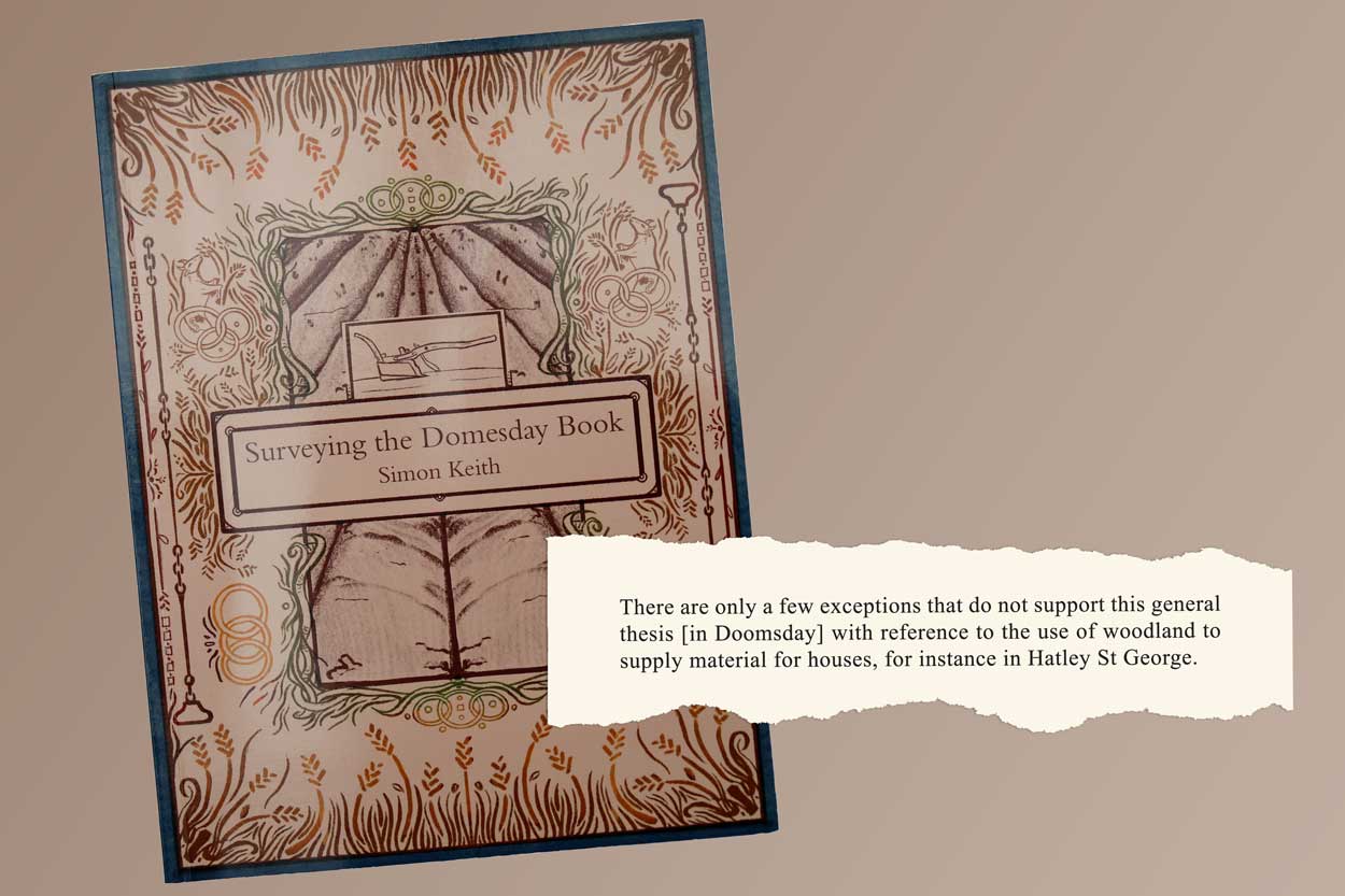
Page 46
There are only a few exceptions that do not support this general thesis [in Doomsday] with reference to the use of woodland to supply material for houses, for instance in Hatley St George. [Because, Simon explains, in the 11th century, woodland was used for grazing and, particularly, foraging pigs.]
Page 92
East Hatley’s only specific mention – and that in relation to the geographic order of travel of the Doomsday inspectors when they came to the Armingford Hundred: Steeple Morden, Tadlow, Guilden Morden, Clopton and East Hatley before going to Croydon and the other eight villages in this Hundred.
Here’s a fuller description of the book – worth reading because it adds to the sum of human knowledge, rather than any Hatley connection – by its publishers, Windgather Press:
The Domesday Book, commissioned in December 1085 by order of William The Conqueror, is generally thought to have been used to assess wealth and assets to collect taxes, and represents an incredible wealth of information on land-use, local economies, and even land disputes between neighbours.
This innovative analysis of the Domesday book from the perspective of a professional land surveyor and valuer aims to calculate a timetable for its creation, along with analysing the survey’s purpose, the nature of the data collected, and how it was used.
By reverse-engineering the survey, Simon proposes that while the document was an outstanding administrative success as a survey, it was in fact a fiscal failure which was never used directly to collect any taxes.
This fascinating study examines the foundation of the well-established, successful and sophisticated hidage assessments upon which the Domesday book was built, discusses the likely timeline of the survey, and examines the logistical problems which are universal to surveyors throughout history.
Simon Keith MA FRICS is a chartered surveyor qualified in the Rural Practice Division. After seven years in private practice with a UK national firm, he served 20 years in the Inland Revenue Valuation Office, latterly as Assistant Chief Valuer.
He was Chief Executive of the Commonwealth Association of Surveying and Land Economy for five years. He was Senior Land Tenure Officer in the Food and Agriculture Organization of the United Nations until retiring in 1999. He was employed over a 35-year period as a consultant in 30 countries for the World Bank and many of the other multi-national organisations and national aid agencies.
Page created 26th November 2019; updated 2nd May 2023.